Splat-Nav: Safe Real-Time Robot Navigation in Gaussian Splatting Maps
作者: Timothy Chen, Ola Shorinwa, Joseph Bruno, Aiden Swann, Javier Yu, Weijia Zeng, Keiko Nagami, Philip Dames, Mac Schwager
分类: cs.RO
发布日期: 2024-03-05 (更新: 2025-01-11)
🔗 代码/项目: GITHUB | PROJECT_PAGE
💡 一句话要点
提出Splat-Nav以解决实时机器人导航安全性问题
🎯 匹配领域: 支柱三:空间感知与语义 (Perception & Semantics)
关键词: 实时导航 机器人技术 高斯喷溅 安全规划 视觉位姿估计 动态环境 Bézier曲线
📋 核心要点
- 现有的机器人导航方法在动态环境中存在安全性不足和实时性差的问题,限制了其应用。
- Splat-Nav通过引入安全规划模块和基于视觉的位姿估计模块,提供了一种新的高效导航解决方案。
- 实验结果表明,Splat-Nav在安全性和速度上均优于传统的点云方法,能够实现实时导航。
📝 摘要(中文)
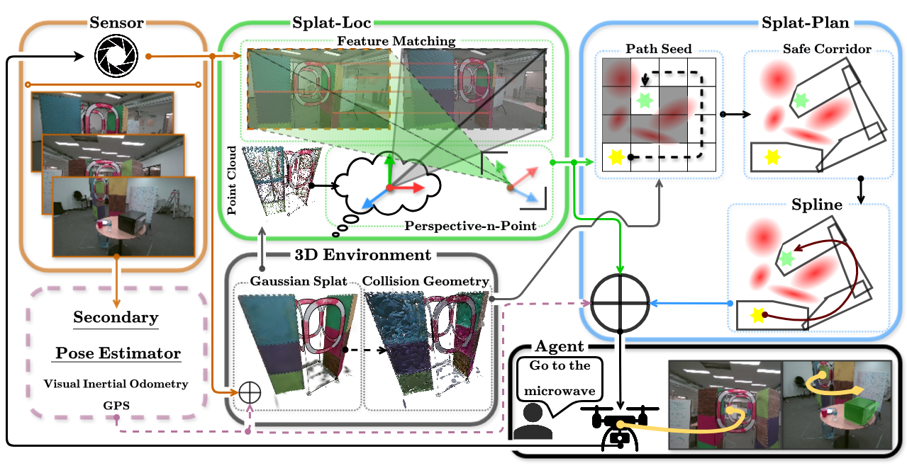
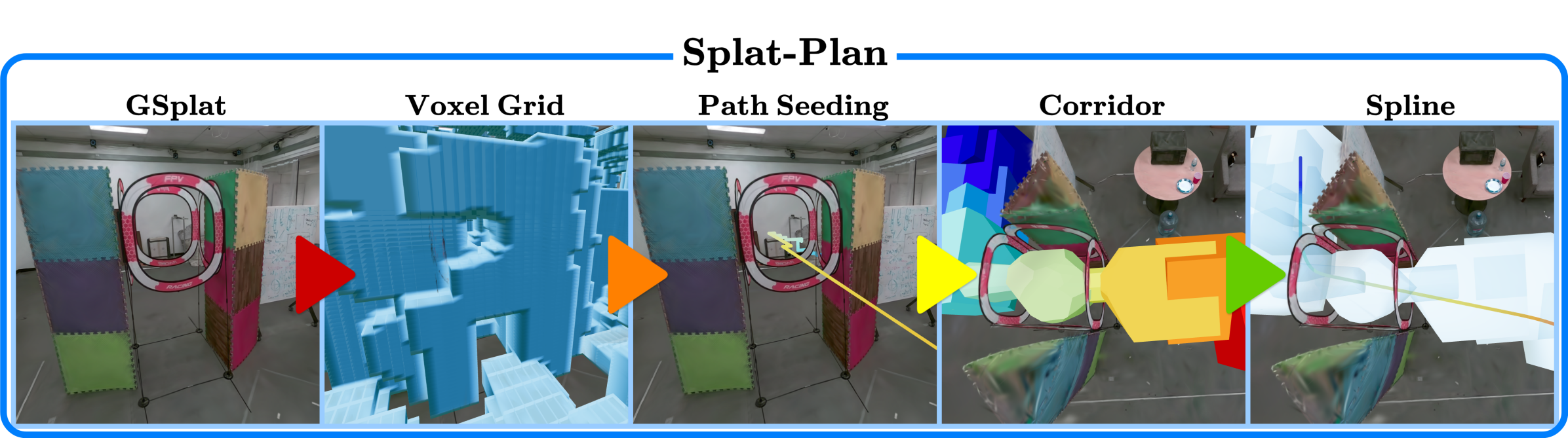
我们提出了Splat-Nav,一个用于高斯喷溅(GSplat)场景的实时机器人导航管道。Splat-Nav由两个组件组成:1)Splat-Plan,一个安全规划模块;2)Splat-Loc,一个基于视觉的稳健位姿估计模块。Splat-Plan根据数学严格的碰撞约束构建安全的多面体走廊,并通过该走廊构建Bézier曲线路径。Splat-Loc利用GSplat场景固有的点云表示,提供仅基于RGB摄像头的实时递归状态估计。两个模块协同工作,使机器人能够递归重新规划平滑且安全的轨迹。我们在广泛的仿真实验中展示了相较于点云方法的安全性提升。在126次硬件飞行中,我们展示了与运动捕捉和视觉里程计相当的安全性和速度,但无需手动帧对齐。我们实现了超过2 Hz的在线重新规划和约25 Hz的位姿估计,速度比基于神经辐射场(NeRF)的方法快一个数量级,从而实现实时导航。
🔬 方法详解
问题定义:本论文旨在解决机器人在动态环境中进行安全实时导航的问题。现有方法在碰撞检测和路径规划方面存在不足,导致安全性和实时性无法兼顾。
核心思路:Splat-Nav通过结合安全规划和视觉位姿估计,利用高斯喷溅场景的点云表示,提供了一种高效且安全的导航方式。这样的设计使得机器人能够在复杂环境中快速反应并调整路径。
技术框架:Splat-Nav的整体架构包括两个主要模块:Splat-Plan和Splat-Loc。Splat-Plan负责构建安全的多面体走廊并生成Bézier曲线轨迹,而Splat-Loc则通过RGB摄像头实时估计机器人的位姿。
关键创新:最重要的技术创新在于Splat-Plan模块的安全规划能力,通过数学严格的碰撞约束确保路径的安全性,这在现有的点云导航方法中是缺乏的。
关键设计:在Splat-Plan中,采用了多面体走廊的构建方法,并通过Bézier曲线实现平滑轨迹;Splat-Loc则利用递归状态估计技术,确保在动态环境中快速适应。
🖼️ 关键图片
📊 实验亮点
实验结果显示,Splat-Nav在126次硬件飞行中实现了与运动捕捉和视觉里程计相当的安全性和速度,且无需手动帧对齐。在线重新规划频率超过2 Hz,位姿估计频率约为25 Hz,显著快于基于NeRF的方法,展示了其在实时导航中的优势。
🎯 应用场景
Splat-Nav的研究成果在自动驾驶、无人机导航和服务机器人等领域具有广泛的应用潜力。其高效的实时导航能力可以提升机器人在复杂环境中的安全性和灵活性,推动智能机器人技术的进一步发展。
📄 摘要(原文)
We present Splat-Nav, a real-time robot navigation pipeline for Gaussian Splatting (GSplat) scenes, a powerful new 3D scene representation. Splat-Nav consists of two components: 1) Splat-Plan, a safe planning module, and 2) Splat-Loc, a robust vision-based pose estimation module. Splat-Plan builds a safe-by-construction polytope corridor through the map based on mathematically rigorous collision constraints and then constructs a Bézier curve trajectory through this corridor. Splat-Loc provides real-time recursive state estimates given only an RGB feed from an on-board camera, leveraging the point-cloud representation inherent in GSplat scenes. Working together, these modules give robots the ability to recursively re-plan smooth and safe trajectories to goal locations. Goals can be specified with position coordinates, or with language commands by using a semantic GSplat. We demonstrate improved safety compared to point cloud-based methods in extensive simulation experiments. In a total of 126 hardware flights, we demonstrate equivalent safety and speed compared to motion capture and visual odometry, but without a manual frame alignment required by those methods. We show online re-planning at more than 2 Hz and pose estimation at about 25 Hz, an order of magnitude faster than Neural Radiance Field (NeRF)-based navigation methods, thereby enabling real-time navigation. We provide experiment videos on our project page at https://chengine.github.io/splatnav/. Our codebase and ROS nodes can be found at https://github.com/chengine/splatnav.