UAV-assisted Visual SLAM Generating Reconstructed 3D Scene Graphs in GPS-denied Environments
作者: Ahmed Radwan, Ali Tourani, Hriday Bavle, Holger Voos, Jose Luis Sanchez-Lopez
分类: cs.RO
发布日期: 2024-02-12
备注: 8 pages, 7 figures, 3 tables
DOI: 10.1109/ICUAS60882.2024.10556948
💡 一句话要点
提出无人机辅助视觉SLAM以解决GPS缺失环境中的3D场景重建问题
🎯 匹配领域: 支柱三:空间感知与语义 (Perception & Semantics)
关键词: 视觉SLAM 无人机 3D场景重建 室内导航 GPS缺失环境 语义信息 拓扑关系 环境感知
📋 核心要点
- 在GPS缺失的环境中,现有的定位和地图重建方法面临可靠性不足的挑战。
- 本文提出了一种集成VSLAM的无人机系统,通过标记结构元素并生成语义丰富的场景图来增强环境感知。
- 实验结果显示,该系统在多种室内场景中能够与真实数据良好匹配,表现出色。
📝 摘要(中文)
本文研究了在GPS缺失环境中,利用无人机进行室内环境地图重建和3D场景图生成的问题。通过搭载RGB-D相机的无人机,结合视觉同时定位与地图构建(VSLAM)框架,系统能够识别结构元素并生成包含语义信息的多层次场景图。实验结果表明,该系统在不同室内布局下表现良好,能够有效提升机器人的环境感知能力。
🔬 方法详解
问题定义:本文旨在解决无人机在GPS缺失环境中进行室内地图重建和定位的挑战。现有方法在复杂环境中往往无法提供可靠的感知结果。
核心思路:通过搭载RGB-D相机的无人机,结合视觉同时定位与地图构建(VSLAM)框架,系统能够识别和标记室内环境中的结构元素,从而生成更高层次的语义信息。
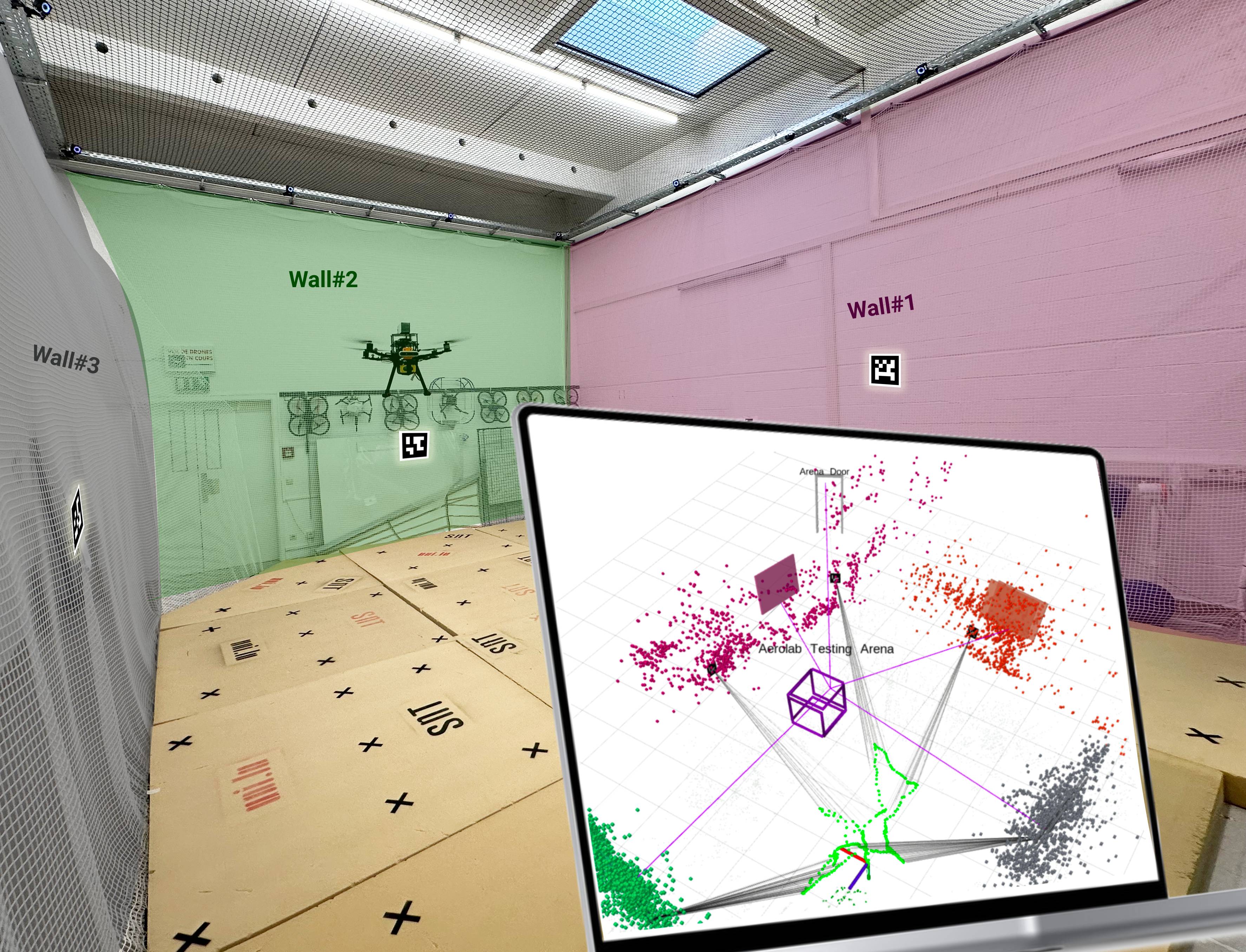
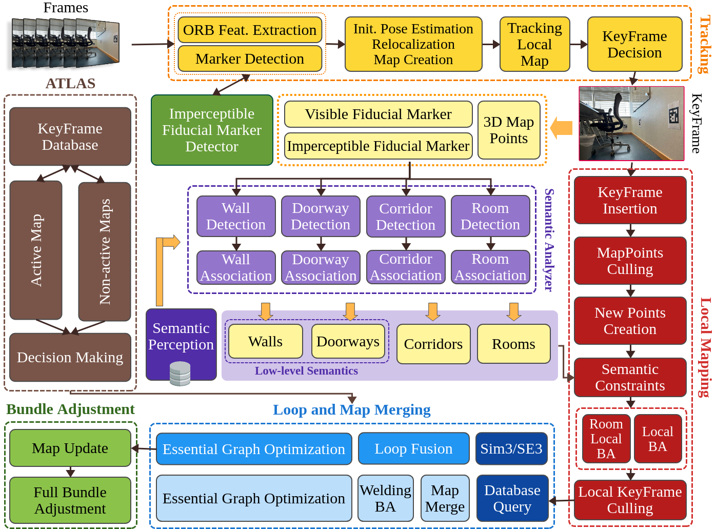
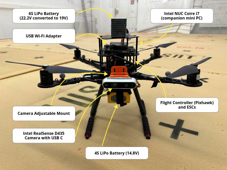
技术框架:整体架构包括无人机、RGB-D相机和伴随计算机,VSLAM系统负责实时定位和地图构建,同时通过识别标记生成3D场景图。主要模块包括传感器数据采集、特征提取、地图重建和语义标注。
关键创新:本研究的创新点在于将VSLAM与结构元素标记相结合,生成包含语义信息的多层次场景图。这一方法显著提升了室内环境的理解能力。
关键设计:系统设计中使用了打印的标记来识别门和墙等结构元素,并建立了它们之间的拓扑关系字典,以增强地图的语义信息。
🖼️ 关键图片
📊 实验亮点
实验结果表明,所提出的无人机系统在不同室内布局下的表现与真实数据高度一致,能够有效进行地图重建和定位,提升了环境感知能力。具体性能数据未详细列出,待进一步验证。
🎯 应用场景
该研究的潜在应用领域包括室内导航、无人机巡检和灾后救援等场景,能够为无人机在复杂环境中的自主操作提供支持。未来,随着技术的进步,该系统有望在更多实际应用中发挥重要作用。
📄 摘要(原文)
Aerial robots play a vital role in various applications where the situational awareness of the robots concerning the environment is a fundamental demand. As one such use case, drones in GPS-denied environments require equipping with different sensors (e.g., vision sensors) that provide reliable sensing results while performing pose estimation and localization. In this paper, reconstructing the maps of indoor environments alongside generating 3D scene graphs for a high-level representation using a camera mounted on a drone is targeted. Accordingly, an aerial robot equipped with a companion computer and an RGB-D camera was built and employed to be appropriately integrated with a Visual Simultaneous Localization and Mapping (VSLAM) framework proposed by the authors. To enhance the situational awareness of the robot while reconstructing maps, various structural elements, including doors and walls, were labeled with printed fiducial markers, and a dictionary of the topological relations among them was fed to the system. The VSLAM system detects markers and reconstructs the map of the indoor areas enriched with higher-level semantic entities, including corridors and rooms. Another achievement is generating multi-layered vision-based situational graphs containing enhanced hierarchical representations of the indoor environment. In this regard, integrating VSLAM into the employed drone is the primary target of this paper to provide an end-to-end robot application for GPS-denied environments. To show the practicality of the system, various real-world condition experiments have been conducted in indoor scenarios with dissimilar structural layouts. Evaluations show the proposed drone application can perform adequately w.r.t. the ground-truth data and its baseline.