Osprey: Multi-Session Autonomous Aerial Mapping with LiDAR-based SLAM and Next Best View Planning
作者: Rowan Border, Nived Chebrolu, Yifu Tao, Jonathan D. Gammell, Maurice Fallon
分类: cs.RO
发布日期: 2023-11-06 (更新: 2024-08-15)
备注: 25 pages, 15 figures, 3 tables. Video available at https://www.youtube.com/watch?v=CVIXu2qUQJ8 Dataset available at https://dynamic.robots.ox.ac.uk/datasets/oxford-osprey
期刊: IEEE Transactions on Field Robotics (T-FR), vol. 1, pp. 113-130, 2024
💡 一句话要点
提出Osprey以实现多次自主航拍和LiDAR映射
🎯 匹配领域: 支柱三:空间感知与语义 (Perception & Semantics)
关键词: 自主航拍 LiDAR技术 多会话映射 任务规划 工业检查 农业监测 点云处理
📋 核心要点
- 现有的航拍系统在复杂3D结构的自主映射中存在效率低下和覆盖不足的问题。
- Osprey系统通过在线映射和任务规划,实现了多次自主航拍,简化了操作流程。
- 实验结果表明,Osprey在2528平方米的区域内,使用112分钟的自主飞行时间,覆盖率显著高于传统方法。
📝 摘要(中文)
航拍系统在许多测绘应用中至关重要,如工业检查和农业监测。虽然现有的航拍平台可以半自主地执行GPS引导的预定任务,但完全自主的系统能够显著提高效率。本文提出了Osprey,一个具有先进多会话LiDAR映射能力的自主航拍系统。该系统允许非专业操作员指定一个有限的目标区域,航拍平台可以在多次飞行中自主完成映射。Osprey在实地实验中展示了其在大型工业场地的映射覆盖率超过手动调查和地面激光扫描仪的能力。
🔬 方法详解
问题定义:本文旨在解决现有航拍系统在复杂环境中自主映射效率低和覆盖不足的问题。传统方法依赖人工操作,难以实现高效的多次航拍任务。
核心思路:Osprey系统通过结合LiDAR技术和下一最佳视图规划,实现了自主航拍和在线任务规划,允许用户轻松指定目标区域。
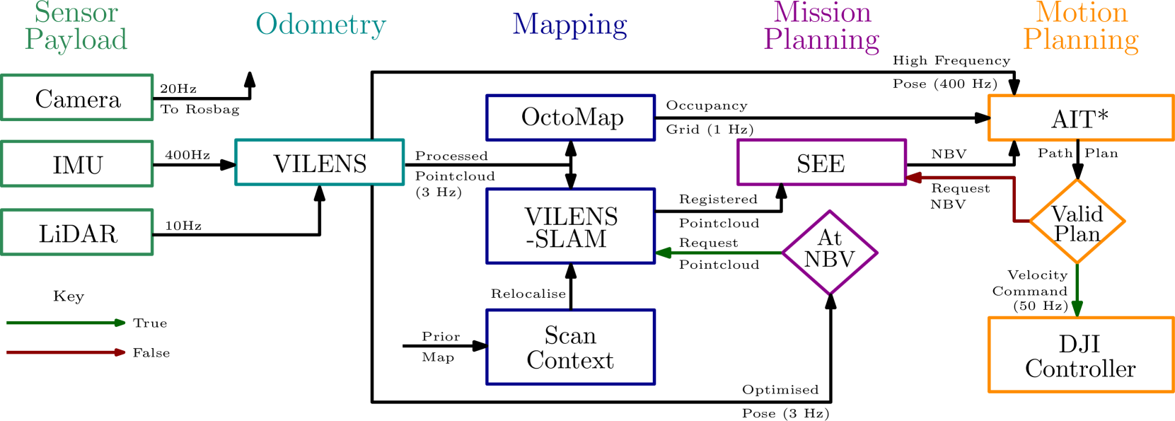
技术框架:Osprey的整体架构包括数据采集模块、实时映射模块和任务规划模块。数据采集模块使用LiDAR传感器获取环境信息,实时映射模块进行数据处理和地图生成,任务规划模块负责优化飞行路径。
关键创新:Osprey的主要创新在于其多会话映射能力,能够在多个飞行任务中逐步完善地图,与传统单次映射方法相比,显著提高了覆盖率和效率。
关键设计:系统采用了先进的点云处理算法和NeRF重建方法,确保生成的真实彩色地图具有高精度和高分辨率。关键参数设置包括飞行高度、速度和LiDAR扫描频率等。
🖼️ 关键图片

📊 实验亮点
Osprey在三个不同场地的实验中,成功覆盖了2528平方米的区域,使用112分钟的自主飞行时间,映射覆盖率显著高于传统手动调查和地面激光扫描仪,展示了其在复杂环境下的优越性和实用性。
🎯 应用场景
Osprey系统在工业检查、农业监测和环境评估等领域具有广泛的应用潜力。其自主航拍能力能够显著提高数据采集的效率和准确性,降低人力成本,推动无人机技术在各行业的应用发展。未来,Osprey有望与其他智能系统结合,实现更复杂的任务规划和执行。
📄 摘要(原文)
Aerial mapping systems are important for many surveying applications (e.g., industrial inspection or agricultural monitoring). Aerial platforms that can fly GPS-guided preplanned missions semi-autonomously are already widely available but fully autonomous systems can significantly improve efficiency. Autonomously mapping complex 3D structures requires a system that performs online mapping and mission planning. This paper presents Osprey, an autonomous aerial mapping system with state-of-the-art multi-session LiDAR-based mapping capabilities. It enables a non-expert operator to specify a bounded target area that the aerial platform can then map autonomously over multiple flights. Field experiments with Osprey demonstrate that this system can achieve greater map coverage of large industrial sites than manual surveys with a pilot-flown aerial platform or a terrestrial laser scanner (TLS). Three sites, with a total ground coverage of $2528$ m$^2$ and a maximum height of $27$ m, were mapped in separate missions using $112$ minutes of autonomous flight time. True colour maps were created from images captured by Osprey using pointcloud and NeRF reconstruction methods. These maps provide useful data for structural inspection tasks.