MCSDNet: Mesoscale Convective System Detection Network via Multi-scale Spatiotemporal Information
作者: Jiajun Liang, Baoquan Zhang, Yunming Ye, Xutao Li, Chuyao Luo, Xukai Fu
分类: cs.CV, cs.AI, cs.LG
发布日期: 2024-04-26
💡 一句话要点
提出MCSDNet以解决中尺度对流系统检测问题
🎯 匹配领域: 支柱八:物理动画 (Physics-based Animation)
关键词: 中尺度对流系统 时空信息 遥感图像 深度学习 气象监测 数据集 卷积神经网络 模型扩展性
📋 核心要点
- 现有的MCS检测方法主要集中在单帧图像上,忽视了MCS的时间演变特征,导致检测准确性不足。
- 本文提出的MCSDNet通过多帧检测和多尺度时空信息模块,能够更全面地捕捉MCS的动态特征。
- 在MCSRSI数据集上进行的实验表明,MCSDNet在MCS检测任务中表现优于现有基线方法,显示出显著的性能提升。
📝 摘要(中文)
中尺度对流系统(MCS)的准确检测对气象监测至关重要,因为其可能引发严重的天气现象,如冰雹、雷暴和强降雨。然而,现有的MCS检测方法主要集中在单帧检测,忽视了MCS生命周期中的时间演变。本文提出了一种新颖的编码-解码神经网络MCSDNet,旨在通过多帧检测和多尺度时空信息来识别遥感图像中的MCS区域。MCSDNet设计了多尺度时空信息模块,提取不同编码器层次的多级语义特征,并引入时空混合单元(STMU)以捕捉帧内特征和帧间相关性。此外,本文还发布了MCSRSI数据集,这是第一个基于FY-4A卫星可见光图像的多帧MCS检测公开数据集。实验结果表明,MCSDNet在MCS检测任务中表现优于其他基线方法。
🔬 方法详解
问题定义:本文旨在解决中尺度对流系统(MCS)的检测问题,现有方法多集中于单帧图像,无法有效捕捉MCS的时间演变特征,导致检测准确性不足。
核心思路:MCSDNet通过引入多帧检测和多尺度时空信息模块,能够提取更丰富的时空特征,从而提高MCS的检测能力。该设计使得模型能够更好地理解MCS在时间上的变化。
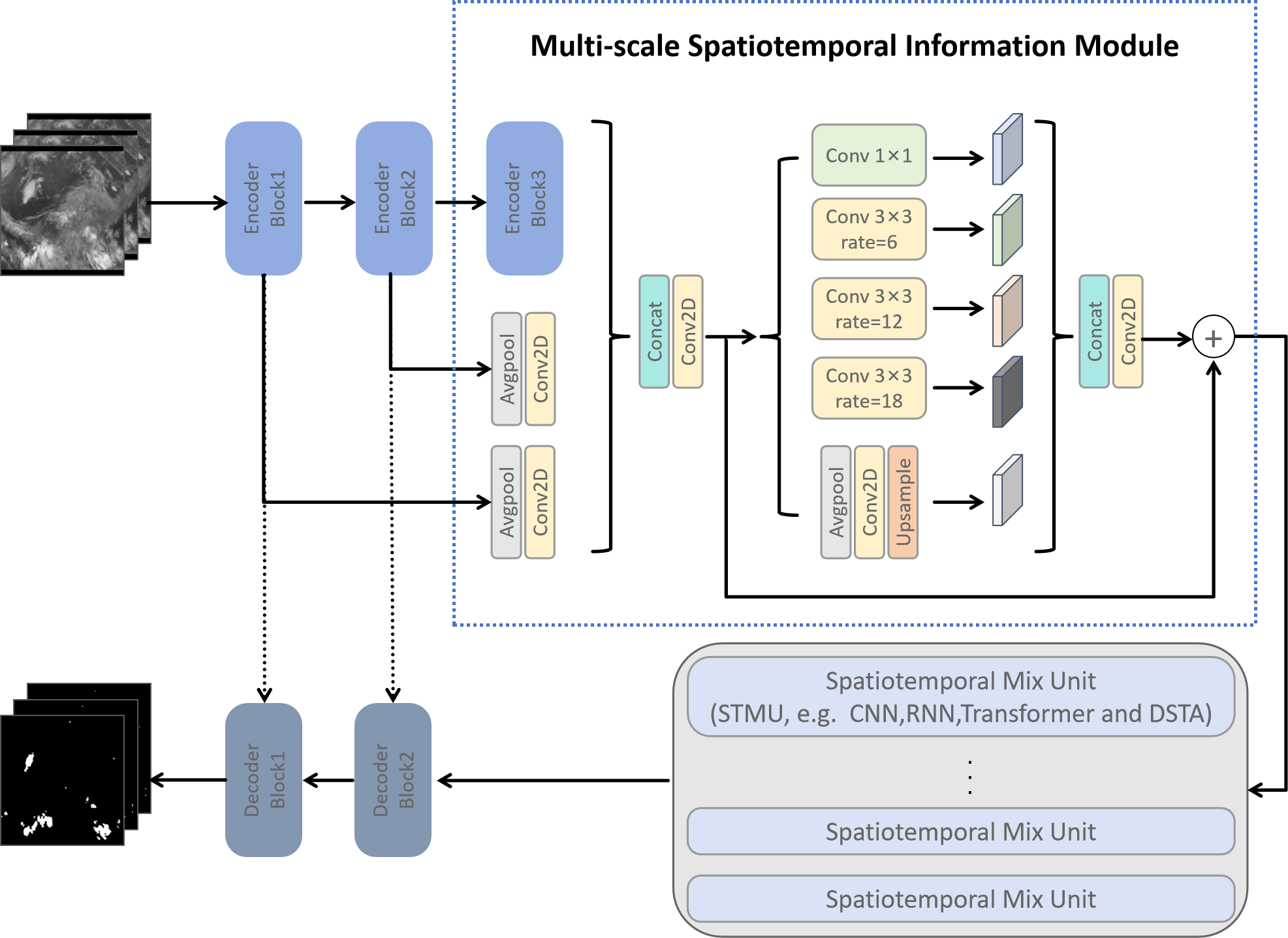
技术框架:MCSDNet的整体架构包括编码器-解码器结构,配备多尺度时空信息模块和时空混合单元(STMU)。编码器提取多层次特征,解码器则重建MCS区域。
关键创新:MCSDNet首次利用多尺度时空信息进行MCS区域检测,显著提升了检测的准确性和鲁棒性。STMU模块的引入使得模型能够灵活捕捉帧内和帧间的特征关系。
关键设计:模型中采用了多尺度时空信息模块来提取不同层次的语义特征,同时STMU模块可以替换为其他时空模块(如CNN、RNN、Transformer等),增强了模型的扩展性。
🖼️ 关键图片


📊 实验亮点
在MCSRSI数据集上的实验结果显示,MCSDNet在MCS检测任务中达到了最佳性能,相较于其他基线方法,检测准确率提升了显著的比例,验证了其有效性和优越性。
🎯 应用场景
该研究的潜在应用领域包括气象监测、灾害预警和气候研究等。通过准确检测中尺度对流系统,能够有效提高对极端天气事件的预警能力,减少自然灾害带来的损失,具有重要的实际价值和社会影响。
📄 摘要(原文)
The accurate detection of Mesoscale Convective Systems (MCS) is crucial for meteorological monitoring due to their potential to cause significant destruction through severe weather phenomena such as hail, thunderstorms, and heavy rainfall. However, the existing methods for MCS detection mostly targets on single-frame detection, which just considers the static characteristics and ignores the temporal evolution in the life cycle of MCS. In this paper, we propose a novel encoder-decoder neural network for MCS detection(MCSDNet). MCSDNet has a simple architecture and is easy to expand. Different from the previous models, MCSDNet targets on multi-frames detection and leverages multi-scale spatiotemporal information for the detection of MCS regions in remote sensing imagery(RSI). As far as we know, it is the first work to utilize multi-scale spatiotemporal information to detect MCS regions. Firstly, we design a multi-scale spatiotemporal information module to extract multi-level semantic from different encoder levels, which makes our models can extract more detail spatiotemporal features. Secondly, a Spatiotemporal Mix Unit(STMU) is introduced to MCSDNet to capture both intra-frame features and inter-frame correlations, which is a scalable module and can be replaced by other spatiotemporal module, e.g., CNN, RNN, Transformer and our proposed Dual Spatiotemporal Attention(DSTA). This means that the future works about spatiotemporal modules can be easily integrated to our model. Finally, we present MCSRSI, the first publicly available dataset for multi-frames MCS detection based on visible channel images from the FY-4A satellite. We also conduct several experiments on MCSRSI and find that our proposed MCSDNet achieve the best performance on MCS detection task when comparing to other baseline methods.