GeoChat: Grounded Large Vision-Language Model for Remote Sensing
作者: Kartik Kuckreja, Muhammad Sohail Danish, Muzammal Naseer, Abhijit Das, Salman Khan, Fahad Shahbaz Khan
分类: cs.CV, cs.AI
发布日期: 2023-11-24
备注: 10 pages, 4 figures
🔗 代码/项目: GITHUB
💡 一句话要点
提出GeoChat以解决遥感领域对话模型的局限性
🎯 匹配领域: 支柱九:具身大模型 (Embodied Foundation Models)
关键词: 遥感 视觉语言模型 多模态学习 对话系统 区域推理 空间定位
📋 核心要点
- 现有的通用视觉语言模型在遥感图像处理上表现不佳,导致信息不准确或虚构。
- GeoChat是首个专为遥感设计的VLM,支持高分辨率图像的多任务对话和区域特定查询。
- GeoChat在多项遥感任务上展示了强大的零-shot性能,包括图像和区域描述、视觉问答等。
📝 摘要(中文)
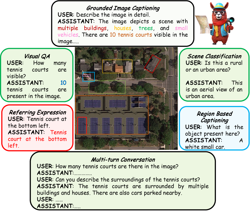
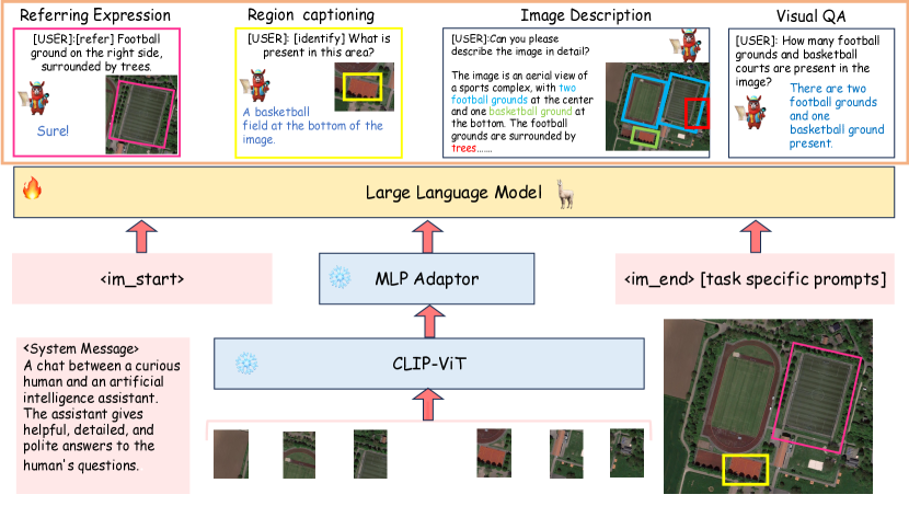
近年来,大型视觉语言模型(VLMs)在自然图像领域取得了显著进展,能够与用户进行关于视觉内容的对话。然而,这些通用领域的VLM在遥感(RS)场景中表现不佳,导致在处理RS领域特定查询时出现不准确或虚构的信息。为了解决这些问题,本文提出了GeoChat,这是首个多功能遥感VLM,能够处理高分辨率RS图像的多任务对话能力。GeoChat不仅可以回答图像级查询,还可以接受区域输入进行区域特定对话,并通过空间坐标对其响应中的对象进行视觉定位。我们还生成了一个新的RS多模态指令跟随数据集,并建立了RS多任务对话的基准。
🔬 方法详解
问题定义:本文旨在解决现有通用VLM在遥感图像处理中的不足,尤其是在高分辨率图像和区域特定查询的场景中,现有模型无法有效理解和回应用户的需求。
核心思路:GeoChat通过引入区域级推理和空间坐标的视觉定位,增强了对遥感图像的理解能力,使得模型能够进行更为精准的对话。
技术框架:GeoChat的整体架构包括图像输入处理、区域特征提取、对话生成模块和视觉定位模块,确保模型能够在多任务场景中灵活应对。
关键创新:GeoChat的主要创新在于其多任务对话能力和区域特定输入处理,这是现有方法所缺乏的,能够有效提升遥感图像的理解和交互能力。
关键设计:在模型设计中,采用了针对遥感数据的特定损失函数和网络结构,确保模型在处理高分辨率图像时的稳定性和准确性。具体的参数设置和训练策略也经过精心调整,以适应遥感领域的特殊需求。
🖼️ 关键图片

📊 实验亮点
GeoChat在多项遥感任务中展现出强大的零-shot性能,例如在图像和区域描述、视觉问答等任务上,相较于基线方法,性能提升显著,具体提升幅度未知,展示了其在遥感领域的应用潜力。
🎯 应用场景
GeoChat的研究成果在遥感监测、环境保护、城市规划等领域具有广泛的应用潜力。通过提升遥感图像的理解和交互能力,GeoChat能够为决策支持提供更为精准的信息,促进智能化管理和可持续发展。
📄 摘要(原文)
Recent advancements in Large Vision-Language Models (VLMs) have shown great promise in natural image domains, allowing users to hold a dialogue about given visual content. However, such general-domain VLMs perform poorly for Remote Sensing (RS) scenarios, leading to inaccurate or fabricated information when presented with RS domain-specific queries. Such a behavior emerges due to the unique challenges introduced by RS imagery. For example, to handle high-resolution RS imagery with diverse scale changes across categories and many small objects, region-level reasoning is necessary alongside holistic scene interpretation. Furthermore, the lack of domain-specific multimodal instruction following data as well as strong backbone models for RS make it hard for the models to align their behavior with user queries. To address these limitations, we propose GeoChat - the first versatile remote sensing VLM that offers multitask conversational capabilities with high-resolution RS images. Specifically, GeoChat can not only answer image-level queries but also accepts region inputs to hold region-specific dialogue. Furthermore, it can visually ground objects in its responses by referring to their spatial coordinates. To address the lack of domain-specific datasets, we generate a novel RS multimodal instruction-following dataset by extending image-text pairs from existing diverse RS datasets. We establish a comprehensive benchmark for RS multitask conversations and compare with a number of baseline methods. GeoChat demonstrates robust zero-shot performance on various RS tasks, e.g., image and region captioning, visual question answering, scene classification, visually grounded conversations and referring detection. Our code is available at https://github.com/mbzuai-oryx/geochat.